June 19th 2023, Moricetown, British Columbia.
The morning I left Jasper in Alberta, the day didn’t seem to know what to do with itself. One minute the sun was beating down on the mountains, picking out all the interesting visual details; the next minute, gloomy clouds would creep in and with them, the rain.
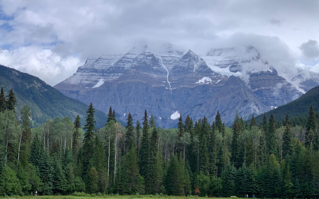
By the time I got to Mount Robson, heading pretty much north-west, about 80 kilometers down Highway 16, the day had settled on being fine but the tops of the mountains still had clouds sitting on them. And that included Mt Robson, at 3,954 meters highest mountain in the Canadian Rockies and looking every inch the bruiser it is.

At Mt Robson, here’s a pit stop information shop for tourists and all the coaches pull in and if you want to go trekking, there are several ways to get around the back of the mountain where its glacier sweeps down into a lake. Behind the shop, there’s a large grassy area in front of a forest of aspens and pines that blanket the flat earth running for a couple of kilometers to the foot of the great mountain. And it really is magnificent — even if its peak is shrouded in low cloud, much to the dismay of the serious minded photographer with his camera mounted on a tripod and just waiting for that charitable puff of wind that will clear the peak for him.
The mountain looks like a series of triangular peaks, each one stacked against another and each rising a little higher until the summit itself emerges. And the horizontal stratification of the limestone rock is picked out in near perfect detail by a dusting of snow that remains, even though we are now half way through June. To the Indians who knew the mountain long before anyone else, those horizontal lines were like a spiral and so they called it the mountain of the spiral road.
Having spent several days in Vancouver and most of a week in Nelson researching the decriminalisation of hard drugs and legalisation of cannabis, and come to the far east of British Columbia, way off my notional route north to Alaska, I really wanted to get back on track. So after paying due respect to Mt Robson, I hit the road northwest for Prince George and stopped again really only twice.
The first was to say hello to a Moose grazing in a field

An adolescent, I think, It seems a bit put out at my attention but wasn’t sure whether to run away. Instead, it did a sort of little circular trot of anxiety before deciding, sensibly, that, meh, he’s just another biker and carried on grazing.
An adolescent, I think, It seems a bit put out at my attention but wasn’t sure whether to run away. Instead, it did a sort of little circular trot of anxiety before deciding, sensibly, that, meh, he’s just another biker and carried on grazing.

The other stop was to examine an abandoned sort of “Little House on the Prairie” near the settlement of McBride that would make a great retirement restoration project . . .
Prince George, when I did get there, didn’t present its best face. The highway skirts around the edge of the town, by the railway tracks and associated post-industrial gunge, and so I just carried on hoping to stumble across a campsite. After about 20 kms, a sign said Northland RV park and so I pulled in. Noreen, the lady who ran it, said they really don’t do camping, just trailer homes on one side of the site and RVs on the other. It was getting late and I must have looked disappointed because, after asking me where I had come from and me telling her the Tip2Top story, she said, “See that green patch over there,” pointing to a lawn on the RV side, “you can camp anywhere over there and I won’t charge you.” And then she asked me how old I was!
Noreen and husband Ernie bought the place a few years back “and then some Chinese with a lot of money offered us a lot of money for it and so now I just manage the place for them and live here”.
“Here” was a very nice and cosy trailer home that had all Noreen and Ernie’s bits and pieces, a small office for the RV business and a nice patio and awning for when the weather was good.

Further up the RV site lived her friends Mike and Wendy in their RV, which had a little fenced-in garden for their two small dogs, and a man shed in which Mike, a trucker, had a sofa on which he sometimes fell asleep and a TV with a pull down white sheet on which he could project films. Mike and Wendy used to live in a house nearby but sold it recently and were planning on going south in the RV but then decided, heck, we just like it here and so they moved the RV into Noreen’s place and that’s now home. Mike made me coffee to welcome me as I pitched my tent for the night.
Next day I awoke to hear the intermittent patter of rain drops on the tent and so I got up fast so that I can dismantle everything and pack it all away before it got soaked. Hitting the road, I set as my target destination for the day, a place named Smithers — 370 kms from Prince George, plus the 20 back there from Noreen’s place, so a round 400 kms. A lot of biking but I really need to crack on and break the back of the 1,200 kms between me and the Yukon.
The only stop I made en route was in a place named Vanderhoof where in an outdoor store for game hunters and fishing, I bought some bear spray.
“You going all the way up 37?” Mike had asked me about the road that branches north off Highway 16. I said I was. “Used to truck up there regular. You’ll see lots and lots of bears. Be careful.”
The spray is a sort of pepper spray cannister gun and so I got a holster too!
I get to Smithers at about 6pm, exhausted but Ok and the municipal campsite is very nicely laid out and well kept, and is by the river in a lovely setting. That evening, I see my first bear — way off upstream on the bank of the river, a medium-sized fellow, as far as I could make out, minding his own business and well out of bear spray range, even if I wanted to zapp him.
Next day, I had a memorable encounter just north of Smithers, at a place named Moricetown. Highway 16 is going through the Bulkley River Valley and its apparent at one point on the road that the river below goes into some falls. A few people have stopped and are looking at what I assume is a pretty sight. It is and I pull over.

Down below, at the Moricetown Falls there are two fellows, one with a very long pole at the end of which is a net. He’s apparently fishing and there’s a side road that goes right down to where he is. I go there, park the bike and get a closer look. The river is really wide and bends into a graceful curve as it approaches a gorge, heralded by big rocks opposite each other, forcing the river into a narrow through which is passes with great force and speed, frothing and roaring all at once. The two men are down on the rocks and so I join them.
They are Myron, who has the pole and net, and Warner, who’s just watching. Both are members of the Wet’suwet’en tribe whose members, maybe 2,000 says Myron, live in this, the Witset Canyon. There’s a channel beside the main fall into the canyon and the water there slips into a large pool and moves on through it much slower than the main body of water. In that channel too, there is a man-made ladder through which fish can swim upstream with greater ease than trying to battle through the man river as it tumbles down the canyon.

Myron is dipping his pole and net deep into the pool, stirring it around and then pulling it out. Nothing.
“No salmon yet,” he says to me. “Next month. Then, they’ll come. First week of July.”
“Will there be many?” I ask.
“Lots,” he says but as many as years ago, apparently.
The annual salmon run is a great occasion for the whole community, it would seem. When the salmon come, people come to the gorge, to the rocks where we now are, on either side, and use nets on long poles to catch the fish.
“Do the bears come too,” I ask.
“Sure, they come! You can see ’em on both banks up there,” he says pointing a little upstream where the river is wide and the water a bit shallower. “We got bangers, bear bangers, and they run back up the banks when they go off but then they get used to them and pay no notice when they go off. It’s the way.”
He tells me I should come back and see it all, maybe on my way back down from Alaska. I tell him I’d like to and I really would! I thank him for chatting, take a couple of pix and we part company. “You betcha,” says Myron by way of goodbye, “see ya soon.”
Back up on the highway and looking down at the gorge, another man is sitting watching the river. His name is Willie.

“Been fishing there 45 years,” he tells me, “we’re part of a dying breed down here. Each year we have maybe 10 poles on either side [of the gorge] and there’s just less salmon.”
He looks across at the far bank of the river and up and down this side too.
‘This used to be all village houses along here,” he said. “But they modernised it. Built new houses up there [he indicates behind, on the far side of the highway] and this is a historical site now.”
I’m not sure whether he’s pleased about that or laments something lost. He says that Myron got a sockeye salmon last Thursday.
There’s no real centre to the village, as far as I can see, but there’s a gas station about 200 meters on that overlooks the village and the gorge. Arnold, an indigenous, and Scotty, who is European Canadian in origin (lots of Irish and Scots in his background, he tells me), join me on a bench by the road.
Arnold looks over at a patch of ground where a digger has removed the shrubs and grass and scoured up the soil but then ceased work.
“See they stopped,” Arnold says.
“I told ’em,” says Scotty, “told ’em there was people buried there. But they didn’t listen just went right on ahead and did it. And dug up bones. Just like I said they would. And now they’ve stopped. People buried all over here,” he said gesturing with a sweep of his arm, making an arc across the whole area.
The plan was, apparently, to create a trek walkway around the village. Scotty was adopted by an indigenous person some 30 years ago. I don’t know if he means formally adopted or just taken under the wing, in a kindly, friendly way these things sometimes happen. We talk about the salmon.
“They’re in,” Scotty says with great certainty. “Can smell ’em now. You smell ’em?” he asks me as if seeking confirmation. “They’re there, that’s for sure.” I can’t smell anything ‘cept my coffee but I tell him Myron got nothing this morning when he went looking, though apparently got lucky last Thursday. “Well, they’re there,” said Scotty, “maybe resting in the pool down there [he points to a part of the river below the gorge]. They’re here. I can smell ’em.”
He says there’s fewer salmon because of bad fish husbandry.
“One of the elders said to me years ago,” he said, “if you take from the river, you have to put back in the river. They ain’t putting nothing back. Nothing about over fishing. It’s all about the spawning beds . . . used to be colder here too in winter. Minus 50 maybe. Now it’s only ever minus 30. Snow only up to here,” he indicated with an open palm waist, as if to suggest it used to be much higher.

I ride and turn up Highway 37, on through Hazelton and into Gitanyow, a tiny village off the highway famous for its totem poles. There are maybe 20 of the giants on a sort of green in the centre, all carved with strange squat figures, little fat men, or that’s how they look, and animals — birds, birdmen and dogs — on ageing and weathered poles perhaps 60 feet tall.
Highway 37 carries on northwards, and me with it. Through valleys and forests, past rivers and lakes of great beauty . . . and evidence of fewer and fewer people. I admit to myself that I’m a little nervous. Next stop: The Yukon.
First published by The Irish Times online on Sunday, June 27th 2023.
