June 23rd 2023, McQuesten, Yukon.
After Whitehorse, I took Highway 2 — the Klondike Highway — straight north towards Dawson City. The Yukon is just over 480,000 square kilometers in size. To give that some perspective, France is 551,000 square kilometers, so The Yukon is big. Really big. The population is a little over 44,000 people, almost all of whom live in or around Whitehorse, the capital city, which is very close to the border with British Columbia. Dawson City, 533 kms to the north of Whitehorse, has a population of under 2,000. Not a lot of people live between the two and those that do usually have a particular reason — they’re indigenous people or do some sort of government work, highway maintenance or wildlife and park ranger, perhaps, or maybe they just don’t want to be near anyone at all, being remote and away from everyone else is their balm.

You can be trundling along the highway for hours and hours and see no one. Between you and the horizon, all 360 degrees of it, whichever way you turn, there’s nothing but forest and mountain. And you come to the realisation very quickly that in the great scheme of all that is around you, and all that is not, you are really quite insignificant.
As you set out on the Klondike Highway, notices advise to start the journey with a full tank of fuel and also tell you where the next gas station is — usually a long way off. The GS has a massive fuel tank — 33 liters, which is enough to last me close to 400 kms — so I usually don’t have a problem. I set out early but then lost time as, after maybe 80 kms, I remembered that I had left my laptop behind at Bruce’s place. Once I remembered, I knew where I’d left it — tucked under a seat on the veranda patio where I was the night before — and I was fairly confident it would still be there. But the best of the day’s biking was gone. I went back and got it and then turned around, and struck out again, stopping after 180kms at a place named Carmacks and the Coal Mine Campground.

I couldn’t see any evidence of coal mining but the camp was on the bank at a bend of the Yukon River — a mighty thing to see! There was a storm and it rained hard initially but I went to sleep with the tent flap open so I could watch the river, maybe 150 meters wide at this point, a pine forest on the other side. The river water was moving with great speed, like a great, fat greeny-grey snake of swirling eddies, with forest debris being swept along. There was fork lightening, jagged shards of it flashing across the sky, and sometimes striking directly down into the ground. Rain bounced off the tent but I still felt secure and dry and when it stopped, a rainbow appeared across the river . . .

Next morning was bright, dry and clear and I set off early and had two memorable encounters.
The first was on high-ish ground between two river crossings — Pelly Crossing, which is a bridge over the Yukon River, and Steward Crossing which is a little further on and is over the Stewart River. Pelly was named, in the 1840s, by explorers from the Hudson’s Bay Company after one of their governors, Sir John Henry Pelly. It was a safe place to cross the river in birchbark canoes and the crossing was done by ferry until the 1950s when the Klondike Highway and bridges were built. At Moose Creek there’s a wonderful old log cabin-cum-store, a relic of says gone by but one that still staggers on. The McQuesten River just down the road is partly clogged by timber debris, of which there’s a lot in most of the rivers I cross.


The road north rose from Pelly Crossing to an upland forested plateau, much of which had been burnt to almost nothing a year ago. Large swathes of the surrounding countryside were huge patches of black where the fires had been allowed simply to burn themselves out.


But suddenly in this desolate place, there appeared cars parked on the side of the roads, or in small areas off it, flat places where sand and gravel had been gouged out, maybe for road building. I stopped when I saw two young-ish people rummaging in the back of their car to ask what they were doing. Mushroom picking, they said. I expressed surprise — and ignorance — noting the devastation of the fire and asking when it occurred. “Last year,” said the man, “yes, it was bad but good for the mushrooms!”
A little further on, at one of the larger sand pit clearings, I spotted two signs: Mushroom Buyer, they said, with little white on black drawings of mushrooms, as one might see in a children’s story book.
I pulled in.
There were a couple of large RV caravans and the detritus of shambolic living — broken stuff and useful stuff all lying around in a mess, with children’s toys also strewn about and a tarpaulin hanging off the side of one caravan, seeming to cover nothing in particular, just flopping there. In the distance, further into the pit, were a couple of cars parked beside tents but no one was visible. And by the entrance itself, opposite the big RV, there was a robust, square beige tent, like something you’d see in a military camp.

Through a flap, a child emerged from it, smiling and curious at me, and then a man. He was the mushroom buyer and he explained what was going on. “The forest burn,” he said with a French-Canadian accent, “and the year after, you go into the forest and pick mushrooms!” I asked what type, thinking they were probably for smoking, and he said they were morel mushrooms, the best of which he said were the blonds and the greys, he said. “last year was a really good season in BC [British Columbia] because of the fires there”.
His name was Phil Lemieux — “French Canadian?” he said throwing my question back at me, “but of course!” he said in that very French way. He was originally from Montreal but had been living in BC for 15 years.
This was his life now. He bought from the pickers, paying them in cash, and sold on to a BC company, West Coast Wildfood. He said about 40 per cent of the pickers were travellers, people from all over the world who moved about all the time, going from harvest to harvest, picking for a living. The rest were opportunists, just picking because the mushrooms were there. After the morels were all harvested, he would go to where the next seasonal wild food could be had. “Now, it is morels and afterwards huckleberry and then chanterelles or pine mushrooms . . . Sometimes, I’m done by my birthday [which is November 19th] and then for the winter, I work in the vineyards [in BC], pruning the vines, until the mushrooms come again”.
He paid the pickers $6 a pound for morels. Some days later, I met another French Canadian woman, known as Melissa of the Woods, who is a morel picker and she said the mushrooms (pictured below) sold at market for between $25 and $30. She picked and tried to sell direct to the consumer, cutting out the buyer-suppliers so she took a greater slice of the money. “I love doing it,” she said, “to be out in the wild, in the bush, with my dog . . . “

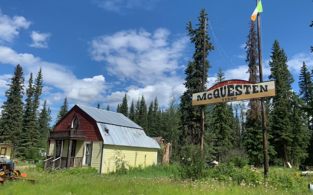
Further along the Klondike Highway, I come across a tumble down mess of three or four buildings, homes in a very poor state but still, on the basis of others I had seen, quite habitable. They seemed to be all part of the one hamlet, which was littered with broken down and otherwise discarded vehicles, but had a way in and out on either side, at either end as the road passed, as it were. One entrance had a gate that was padlocked shut; the other was blocked off by a large truck that looked like it had seen better days. in the middle of the site, there was a large sign, high up on two tall poles, and a cross piece of wood with a place name on it — McQuesten, it announced. The place was apparently named, just like the river, after Jack McQuesten, a miner who became a supplier of goods to miners, bringing what they needed to Dawson City for sale there. But what really caught my attention, and why I stopped, was that on one of the poles there was flying the Irish flag — green, white and orange, clear as anything. There had to be a story behind that, I thought, and so I stopped, edging my way past two RVs that has also pulled in to the side of the road in front of the hamlet.
Two women from the RVs were also wondering about the flag. I explained what it was and its meaning, and they were equally fascinated as to why it was flying there. I said, well one way to find out is to go in and ask — “either I’ll get an answer,” I said, circumventing the blocking truck, “or I’ll get shot.”
Wandering about the site, calling out “hello” every few feet, it appeared to be abandoned. I couldn’t see a car or truck capable of being driven. The building on the right, the one encountered first entering, was half finished. It has a stone first floor but the upstairs was made of timber sheeting that was totally exposed to the elements and was rotting away. The building in the centre was a very cute (or used to be very cute) two storey timber and wall shingle cottage, with a little first floor balcony porch by the front door, and two nice windows on either side of it, and a corrugated iron roof in good condition. But looking in through the front door, I could see that the back of the house was missing — fallen down apparently. The third building was a horrendous mess. Timber sheets and tarpaulins appeared to be in place to keep out the elements and in front of the building, there were several vehicles, none of them appearing like they could move, or had moved in recent times.

“No one there,” I said to one of the ladies who had remained at the gate watching me. And then she told me her story. She was Marit Main (above with her husband) and the little cottage in the centre used to be the home of her grandmother, Solway Dines. What’s more, it used to be in Dawson City. “The people who bought it [there], later sold it and the guy who bought from them it moved it here,” Marit explained. She had visited McQuesten some years ago and at that time, the little cottage was a restaurant and was still in a good state of repair. She said that all the houses in Dawson were built on very short stilts because the permafrost didn’t allow for proper foundations. This meant it was relatively easy to lift a building and move it.
Dave Main, Marit’s husband, said that Solway’s father was a man named John Dines who went from BC to Dawson in 1897. In Dawson, he played a pump organ which the family still had. Apparently, he played it in Diamond Tooth Gerties, a place of high-stepping dancing girls in frilly knickers, of song and dance and drink and probably more besides. On Sundays, John apparently took his organ down the road to the church and played hymns for the faithful.
I never did find out why the Tricolour was flying over McQuesten.
Well done Peter! I am thoroughly enjoying your blog. You seem a very alive soul & brave adventurer!