Fairbanks, Alaska.
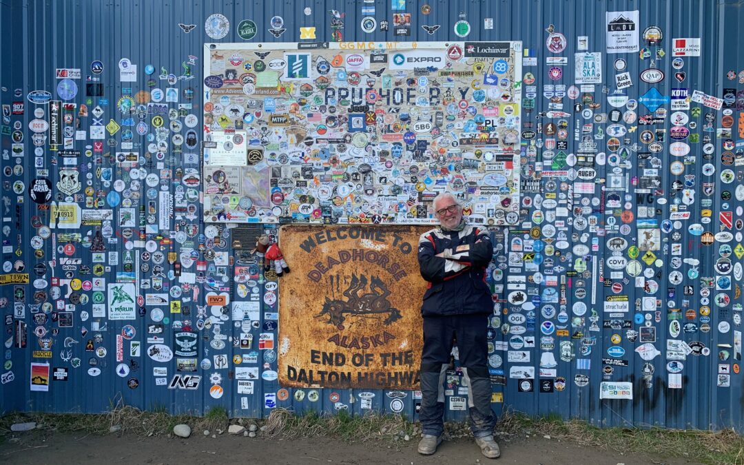
Deadhorse is a 21st century version of a wild west town and it strikes me as a place where just about anything could happen. Well, almost anything: there’ll be no shoot out at the OK corral saloon bar because there ain’t no saloon bar in town. In fact, there’s very little that constitutes a town — just one shop, hardware mainly, and some stickers and t-shirts as an afterthought, and an unmanned gas station. There’s no main square, no church, in fact there’s no public square at all. There’s places to work, big heavy industrial places — land-based oil rigs and the contract operations that serve them — and places to sleep and eat, Hotels, bunk houses, not restaurants, and that’s about it. Deadhorse is dry, totally dry, because of the dangers alcohol poses. Oil drilling operators and the heavy industrial contractors cannot afford, not so much a drunk worker as one operating below par the day after a night on the tiles.
The place didn’t exist in any shape or form before oil. So why Deadhorse, I asked a tour guide of the oilfield. He said one version was that if you got this far, your horse would surely be dead. But the other was that a haulage company involved in bringing gravel for the highway had as their motto “we’ll move anything, even a dead horse” and thus was born the town that ain’t a town.

Some weird things do happen in Deadhorse, I’ll say that.
I’m on the bike at about 8am heading for Deadhorse Camp, a sort of hostel, from where I’ll join the tour of the Prudhoe Oilfield. I’m the last of three vehicles approaching a bend in the road when the first car comes to a halt. The bus in front of me, and behind the car, also stops. And so do I. Initially, I don’t know why we’ve all stopped and then the car starts to reverse and I see the reverse lights of the bus light up. I start to shuffle myself backwards, still not knowing what’s going on. And then I look ahead where the road turns sharply left, and where we were all about to go.

There’s a bear, a very large brown bear, ambling along on all fours, with no obvious sense of mission, from what I could see anyway, but ambling towards us for sure. He’s a Grizzly Bear, which I can tell by the hump on his back, around about where his shoulder blades are — a defining characteristic of the Grizzly. He really is quite large, about the size of a short-legged but overweight bull, and although he’s ambling with a sort of lumbering motion, he has that way about him that has me thinking: “he looks like he could run very fast if he wanted”.
I pull over to the left side of the road and start fumbling urgently for my phone to take pictures as Mr Grizzly moves along the right side, where the vehicles are and where another one has joined the queue behind me. I can see people in the cars are sort of freaking out and the bear apparently tried to open one of the car doors, grabbing the handle in his mouth. My efforts to video Mr Bear fail miserably as, simultaneously, I realise that I too better high tail it out of there, which I do, making a two second video of, I think, the road surface in the process.
“Oh, you’re the guy who was on the bike!” exclaims Sher from Oregon, when she arrives at the Camp, also for the tour, she having been in the other car to pull into the bear queue just behind me. “Oh my God!” she says and then we have the “where are you from” conversation and Sher, the other 20 or so people about to embark on the tour, plus the guide, are all very congratulatory about my journey. Yes, I said, it’s been a long one and this is the end . . .
I pulled into Deadhorse the night before, 797 kms north of Fairbanks. My odometer was showing 37,204 miles, not kilometers ‘cus the bike was bought in the UK. Of those, 13,941 were done before I started this trip. So I reckon it’s been a 23,263 mile adventure, give or take. That’s 37,438 kilometers and at this juncture, I don’t really know what my feelings are. I have a sort of detached conversation with myself in which I say, “well, there you are now, you’ve done it” to which I reply to myself saying, “well, yes, I suppose I have” and fall silent, not knowing what to think or say to myself next.

The Dalton Highway is perhaps the greatest adventure biking road on earth accessible to mortals like myself. It is named in honour of James P Dalton, an Alaskan mining engineer and oil prospector in the tundra area between the Brooks Range and Prudhoe Bay, which is known as the North Slope. He worked with the US Navy’s Alaska oil exploration project and also helped create the Cold War DEW Line, a necklace of early warning radars running from Greenland across North America to western Alaska. The highway was built not by him but by the Alaskan oil industry after confirmation, in the late 1960s, that oil existed in Prudhoe. It was initially a haul road for building the Alaska Oil Pipeline, the 1,300 kms crude oil feedline from Prudhoe to Valdez in southern Alaska. Finding the oil was like a second Alaskan gold rush: the road was built in an incredible 154 days, with 32 million cubic yards of gravel, and the pipeline in just three years, from March 1975 to May 1977. Crude oil began flowing, at 100 degrees F, in 1977 and takes two weeks to reach Valdez. Construction workers, some of whom were Irish, could earn $1,000 to $1,500 a week. Today, the average pay in the oilfield is $150,000 a year.

The pipeline is visible everywhere between Fairbanks and Prudhoe because it runs almost entirely above ground, on steel stilts, about 10 feet tall, sometimes in a straight line, sometimes zig-zagging to help it survive earthquakes. The oil carrying pipe is four feet in diameter but it is sheathed in protective and insulating material making it look fatter. Lots of signs warn the curious to stay away from it and not to climb onto it. The pipeline is a scar on the landscape for sure but I can’t say it has destroyed it — it’s there, yes, but then so is everything else, the scenery, the forests, plants and wildlife, and when the oil runs out, it is supposed to be removed.


Once I got onto the Dalton, just beyond Livengood, some 134 kms north of Fairbanks, I settled into the final ride of this adventure and soon found my anxiety easing. The gravel was hard packed and, crucially, there weren’t greats drifts of it into which a front wheel might sink, causing the bike to shimmy and maybe topple over, me with it. In no time at all I was tootling along at 50 km/h, even when the gravel gave way to stretches of hard packed mud. Fairly early on, there were major road works, perhaps about 20 kms long, where there were lots of diggers, earth movers, dozers, traffic cones, red flags and traffic restrictions. Sometimes one side of the road was closed to traffic and a stop/go system operated for the other side, with cars and trucks being led, when they were allowed to proceed, by a pilot car with a large “Follow Me” sign on the back.
It starts to rain and my heart sinks. The mud surface turns slippery and tyre track gullies form from the lorries. But, as I’ve learnt by this stage, the best tactic is to keep going at a steady, if reduced speed, 20 or 30 km/h for instance, sometimes standing on the footrests (the pegs) for balance and control. It’s strange, but what seems like an inherently unstable tactic actually gives you far greater control — up on the pegs, lean forward, knees clasping the tank and used to jerk the bike away from big holes, rocks or, worst of all, slithery, gloopy canals of mud. I’ve good tyres on — Heidenau Scout K60s — and they hold up really well.
The road works end, the pilot car pulls over and I’m through — elated not to have fallen over, I feel now I really can do this, I am up to the challenge. I feel great and the sense of Wow! is reinforced when I reach Yukon Crossing, an early staging post 224 kms out from Fairbanks, where the Dalton crosses the mighty river and it really is mighty here — enormously wide, a couple of hundred meters I’d say, and starting to enter its old man stage as it moves to the Baring Sea. Just after the crossing, there’s a camp site called, Five Mile Campground which is, by strange coincidence, five miles after the crossing. Amid a blizzard of mosquitos kept at bay by a face net, I get the tent up.

A couple, Bret and Kacey, and their big friendly dog Lila, are camped beside me, sleeping in a pop-up tent on the roof of their car. They love travel so much they decided to sell their home and, well, travel. Bret is a supply chain strategy consultant for retailers, and Kacey works in IT on something known as air tagging. They can do their jobs anywhere . . . and so decided to do just that!
The midnight sun keeps it daytime all the time at this time of year and so I go to sleep in sunshine, and wake up in it too. In between, it rained like hell and so I’m nervous about the road once again but the first challenge is how to get up and dressed without being eaten alive.
Leaving Five Mile Campground, I see there’s an airstrip right beside the road, with two huge yellow X markers stapled into the runway. Soon after, the road rises gently to a plateau named Finger Mountain — so called because of the granite protrusions that in some instances resemble an upright finger sticking out of the bog-like ground. Views of the mountains to the north and east are obscured partly by long streaks of low, early morning clouds but through them, it is still possible to seek snow-flecked mountain tops and winding rivers in the flat floor valleys between them.

Further on, the road passes the only home outside of a couple of settlements on the whole Dalton, that I notice. A two storey wooden house sits across from what looks like a very old log cabin, on which there’s a sign: Old Man Alaska. Although there’s a car, the gate is chained closed and a sign says No Trespassing. Someone wants to be alone, apparently. The oil pipeline runs past the back of the property, within what looks like touching distance.

At the crest of the next hill, which is named, ominously, Beaver Slide, just before I start to descend, a driver coming up lowers his window and shouts out a warning at me: “Muddy. Really muddy . . .” I start the descent fearing the worst but, again, everything is OK — his side of the road looked like thick gravy plasticine but on mine, the ground is firm and easily driven. I reach the Arctic Circle — 318 kms north of Fairbanks — my second time to cross it (the first being north of Bodø in Norway about 44 years ago). Lukas, a young American, is there by the big Arctic Circle sign, latitude 66 degrees 33′. On a bicycle and heading for Ushuaia, in the extreme south of Argentina. So too is motorbiker James from New Zealand, his second time riding this part of the world. What did your wife say when you said you were doing it again, I asked. “Don’t come back,” he said and, by the sound of it, I don’t think he will. After Ushuaia, he’s planning to do the Northwest Territories of Canada.

At Coldfoot, 414 kms from Fairbanks (and 383 from Deadhorse), there’s petrol and coffee, and food if wanted. I ask the girl behind the country how long to Deadhorse? “Five to 12 hours,” she says, “depending how fast you go.” It was coming up to midday and so I reckoned I could do it in seven or eight hours — lots of time, especially with 24 hour daylight. And this part of the journey proves to be the most magical, the most breath-taking, jaw-dropping part of the whole Dalton. The scenery is just incredible.
There’s a valley, much of it with a tarmac road, that passes mountains that are massive in scale — bare rock mountains with jagged edges and coloured rockfaces, towering over rivers and lakes, a raw landscape from which trees are slowly being banished as the road surges northwards. One of the mountains is Sukakpak (1,338m) — jagged and angular, it juts upwards like a broken plank sticking out of the earth. Opposite it, is another, a long bare escarpment above the tree line, an enormous mountain of grey rock with rust-coloured minerals bleeding from it.


The valley leads into the Atigun Pass, the final mountain hurdle through the Brooks Range, where the partly snow-covered mountains are black and look doom-laden, and landslides are a menace preventing any stopping on the road.


I’d been warned by a guide at the Arctic Visitor Centre in Coldfoot that this potentially would be the most difficult part of the road, with unstable gravel and lots of mud. But it wasn’t a problem; the bike handled it without demur, even though heavy rain had appeared making it almost impossible at times to see clearly ahead.
Down onto the rolling landscape that would soon drop onto tundra flat as a pancake, Deadhorse was but 270 kms away. And as I near the end, the struggle between land and ocean sees the landscape become more and more blotched with rivers and lakes and bits of estuary, the wild, bare, windswept Arctic inhabited only by low-growing tundra shrubbery and flowers, birds, caribou and other mammals . . . plus transient oil workers and adventurous visitors.


Officially, no one lives in Deadhorse. They are all temporary — some 5,000 oil workers and about the same again of contractors — names such as Haliburton, Worley (chemicals), Schlumberger (general oilfield services) and MiSwaco (drilling fluids). The oil field has 1,400 wells, of which 800 are active. It is 150 miles across, that is east/west, and 15 to 20 miles deep, ie from the Arctic Ocean shore inland. Huge installations are scattered across the landscape, many behind wire fencing with acres of gravel yards around them in which there are stacks of pipes and bits of equipment, some redundant and ready for scrap, others their replacements. And despite all the heavy industry, nature is everywhere.

“On the right,” says Jack, the guide and bus driver on our oilfield tour, “caribou.” And there, strolling between huge lumps of frontier industry, are half a dozen of the beautiful reindeers, most of them with impressive antlers. An arctic fox, with his dark summer coat on, appears bounding across the tundra. “He’ll be looking for birds eggs,” says Jack. “On the left, a Brent Goose — now, he’s quite rare — those over there are Cackling Geese. They look quite like Canada Geese but have a shorter neck . . .”
We see Great White Fronted Geese, a Snow Goose, Tundra Swan, Long Tailed Sea Ducks and Red-Necked Phalarope. Jack says that Polar Bears are not really a problem in Deadhorse, contrary to what I had been told, but grizzlies are. That much I know personally. Polar Bears do hang out over at a seawater treatment plant, further away, said Jack.
He took us down to the sea — Prudhoe Bay, the Arctic Ocean — gritty sand and sea shells, a peaty shoreline and lots of driftwood timber lying about. It looked like a beach anywhere and yet, here I was, on the edge of the Arctic Ocean, in bright sunshine, at the end of an almost eight month odyssey from Isla Naravino, the extreme far south of Chile, which I left on November 22nd 2022. I’m not a great sea swimmer but I had to get in. I knew that for sure, as did three or four of the others. When I did, I plunged in and swam out a bit and then stood up, the shock of the cold banished by the moment itself.


The others all stood cheering me, and that’s when it hit me, that’s when I felt a bit emotional. This was truly the end. Over 200 days riding the bike, almost every day, and it was over.
I had spent the night in the 432-room Aurora Hotel, serving contractors mainly, a building with all the charm of a prison block, and ate microwaved turkey and rice, and not having a celebratory beer.


I looked across the tundra at the Brooks Range, clear and sharp in the sun, despite the distance. Once again, I rode through the Atigun Pass, through valleys and passed the extraordinary mountains, the rushing rivers and turquoise lakes.
The day was bone dry and on that long flat, compacted mud section of the Dalton before Yukon Crossing, I stood on the pegs, lent forward and hit 70 mph.
Seventy. On the pegs. Aged 70.
Top of the world Ma, top of the world.

Great job Peter. What an. Experience. Hope you’ll give a presentation sometime in Dublin.
Thanks. First task is the book and wading through 12,000+ photographs!!!
Thanks for all that Peter, safe homeward trip.
Wow! Peter! Safe home ! When you expect to arrive back in August ? You are invited to a celebratory coffee or beer when you are ready to hit the streets of Greystones again !
Look forward to that! Hope to be back within about 10 days…
Mazal tov, Peter. Look forward to seeing you in person and hearing about the adventures at first hand
Thanks Ed. Yes, I look forward to that too. We have some catching up to do!
Congratulations ? What an achievement. Thank you for the privilege and fun of following you on this amazing expedition. I am looking forward to the book.
I enjoyed revisiting some of the remote places I too have seen. Patagonia (including Cape Horn), in 2013 and Prudoe Bay in 1988. I rode the Dalton Hwy from Prudoe Bay to Fairbanks on a school bus that summer. In the intervening years I saw parts in-between – Baja California, parts of the west coast from San Diego to Seattle, the Andes and the Rockies, Vancouver and British Columbia, Alberta and South East Alaska. I have crossed the Arctic Circle 6 times and seen Antarctica. I am now approaching 80 and no longer travelling far and wide (but generally safely), so your trip, so brave and adventurous, has given me much pleasure.
Have a safe journey home to your family.
Hey! I doff my hat to you, Lady Adventurer! You have been to so many places, and long before me and many others too, I suspect. I hope your memories were stimulated a little by my efforts and that they continue to sustain you. Best wishes — Peter
Congrats Peter
I’ve loved every minute of your odyssey
Brilliant
Thanks very much; quite liked it myself! Shall have to plot another….
Very well done Peter – I presume there will be a book of some sort out of your wonderful journey
Fingers crossed!
Peter, thanks for sharing all your adventures on the road with us it really was a great journey. Well done again and safe passage home.
You have done it, Peter!!! Yeaaaahhh!!!!! Heartfelt congratulations!!!
Ta muchly! We shall raise a glass in Mossies in a few days, I hope! Love to you both!
Congratulations Peter. Loved the “don’t come back” line. Glad you were on the bike when the grizzly was about. They can run, climb and swim faster. Will miss your posts. Onwards and upwards. Well done.
Thanks Des. Yes, I suspected Mr Grizzly could have given me a good run for my money!
It’s been fantastic following your journey and adventures. A well earned finale, enjoy whatever comes next!
Thank you for sharing your wonderful experiences in Canada ? it gave us back wonderful memories we shared with our Son who lived in Maple Ridge in BC he has since passed but u meet his amazing friends while u were there I believe you helped someone in distress with a moter bike and they spoke highly of you bless and thank you so much .
Ah, thank you. I hope your pals are well and got home safely. I’m on my way back to Ireland any day now!
Well done Peter, I felt I was with you all the way on your epic journey. Fantastic!
Thanks Alvin… and thanks for coming along for the ride, at one remover, as it were. Home safer now and trying to digest the whole caper. It was fun for sure!
Well done, chum! Aye, it’s a weird feeling, finishing, isn’t it? Half elation and half deflation, but great achievement; and of course you hit the nightlife centre of the entire trip, at Gobblers Knob 🙂 See you soon when you get home!
Thanks pal. Yes, weird for sure. Still don’t know what to make of it all! Back in Greystones now but waiting for word from London that the bike is there sop I may go and collect it.Must have a run together soon! Best to Cate….
Congratulations , it’s been a great journey for all us readers too. Safe home.
Congratulations, Peter! Well done. We’ve enjoyed reading your blog and can I say that your previous entry (“you may not hear from me for a while”) had us a bit worried. Was great to see you in San Francisco and hope to see you back in Ireland.
Ha! Thank you. Yes, that last line was a bit of a teaser! 🙂
Great job Peter – you remind me of me!!!! My plan is to get up to Prudoe Bay next June-July from Calgary.
Excellent! I wish you well and hope you have as easy a journey as I did. The weather (ie rain) was on my wide on the Dalton…
Welcome home, Peter, after a wonderful journey – what an achievement!
Many thanks again for this blog, which I really enjoyed reading – in particular for a sense of South and Central America (which I have never visited), and for reminders of two great driving trips in British Columbia (’07) and California/Nevada/Utah (’09).
Hope the anticlimax is not too hard to handle….!
Best wishes with the book
Well done Peter!
Great achievement.
I´ll miss the interesting blogs.
What the highlights and lowlights of the trip?
Con